Midway Island

logo


Midway Island Facts

Latitude: 28° 12' N.
Longitude: 177° 22' W.

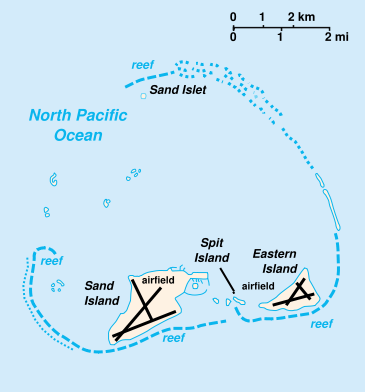
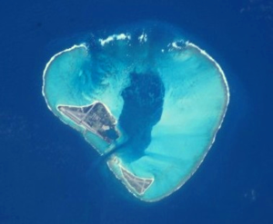
Midway Atoll is an unorganized, unincorporated territory of the United States. It is less than 140 nautical miles (259 km; 161 mi) east of the International Date Line, about 2,800 nautical miles (5,200 km; 3,200 mi) west of San Francisco and 2,200 nautical miles (4,100 km; 2,500 mi) east of Tokyo. It consists of a ring-shaped barrier reef and several sand islets. The two significant pieces of land, Sand Island and Eastern Island, provide habitat for hundreds of thousands of seabirds.

Midway Island, Hawaii, United States Weather Forecast

Below is a map drived from CIA drawings. Our operation will take place from Sand Island.

map

Links:

The Battle of Midway
US Navy Video of The Battle of Midway
US Navy Story of the work of the Cryptologists to break JN-25
US Navy Art commemorating The Battle of Midway
Official F & W Midway website
NOAA Weather Alerts
Fish & Wildlife Announcement of Ham Radio Operations
Website run by WA8ICK commemorating the Navy airmen who flew during the cold war as an early warning system. Jack and many other hams were stationed on Midway.


This page sponsored by:

This ad could be yours

You are visitor number:

custom counter

{ First Page | Midway Island Info | Foundation/Club Sponsors | Individual Sponsors | QSL info | Team Members | QRGs and Greyline }

Last updated 21 September 2009